Please note that gps4cam desktop requires gps4cam or gps4cam pro (iOS apps) that record your GPS locations in order to geotag your photos.
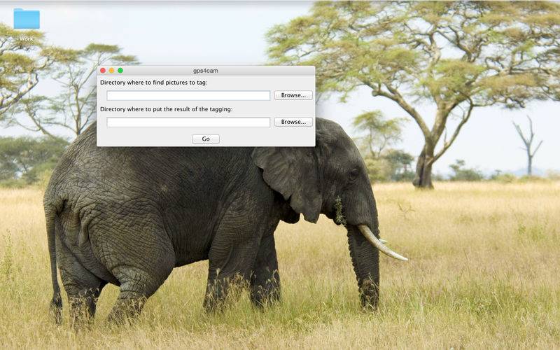
gps4cam desktop is the desktop tool that allows you to geotag your photos taken with any digital camera. Gps4cam for desktop needs your photos as well as gps4cam (mobile app) data as inputs. In others words, all you need to do is to specify the folder containing the photos to be geotagged and the QRCodes generated by the mobile app gps4cam. Gps4cam for desktop will run, geotag your photos and put them with a GPX file in the folder you’ve specified before starting the process.
For advanced settings, go to “Preferences” tab and you will find the following features:
1.QRCodes search method: you can choose between the following methods:
•Only search in last photographed pictures: this is the default option and it helps you geotag in a quicker way because gps4cam desktops looks for the QRCodes only in the last photographed pictures
•Search in every picture except those photographed during a decoded trip: This option is convenient when the input folder contains several trips which makes the QRCodes not only on the last photographed pictures.
•Let the user choose pictures in which the search will be done: This is a manual process that gives the user the ability to choose directly the QRCodes which will be used to geotag the pictures.
2.QRCodes decoding: Options for QRCodes decoding
•Fast QRCodes decoding: You can check this option if you want
•Use dcraw instead of Exiftool to read RAW photos files: Gps4cam desktop uses Exiftool by default to read RAW files. If you prefer to use dcraw then you only need to check this option and specify the local path
3.Photo geotagging: advanced options for photo geotagging
•Write altitudes if they are available: This option is checked by default and lets gps4cam desktop to write altitudes in the metadata of your pictures whenever they are available
•Geotag photos in their origin directory: Checking this option, will allow you to directly geotag your original photos in their original folder without duplicating them
•Output GPX file in origin directory: This option let you add the GPX file in the original folder
•Overwrite GPS data in metadata if already existing: By default, gps4cam skips all the pictures that are already geotagged. By checking this option, you allow gps4cam to overwrite geotagging data even when the picture is already geotagged.
4.Time stamping: Below the time stamping options
•Correct the creation date of the photo in metadata with phone local time: This option is enabled by default and allows gps4cma desktop to replace the creation date of the photo in metadata by the phone’s local time at the moment it was geotagged. This option lets you photograph and geotag without having to setup your camera’s time to match your phone’s time.
•Overwrite output files creation/modification dates with dates in metadata: This option allows gps4cam to overwrite creation/modification dates of your pictures with the dates present in the metadata.
5.XMP support: full support of XMP files. As know, some cameras generates for each picture an XMP files containing all the metadata.
•Read information in XMP file if exists (instead of photo file): This option allows gps4cam to read XMP files (if existing) instead of the photo metadata
•Write GPS coordinates in the XMP file (instead of photo file): This option allows gps4cam to write GPS data in XMP files (if existing) instead of the photo metadata
•Write corrected date in the XMP file (instead of photo file): This option allows gps4cam to write date/time data in XMP files (if existing) instead of the photo metadata
6.Advanced
•Ignore all warnings: This option allows you to ignore all the warnings you can get during the geotagging process. It is recommended only for users who frequently uses gps4cam
•Priority to GPS timestamp field to get date/time of photos (not recommended)
•Files to take into account