Magic Maps is a tool for creating beautiful, informative maps. It includes a rich feature set and is much easier to use than high-end GIS packages. Here are some things you might do with Magic Maps:
• Color states or countries using data from a CSV file
• Create a custom map of sales territories
• Export a movie file showing how data have changed over time
• Mash up Shapefiles, GeoTIFF files, and custom points into a single map document
• Convert ArcGIS Shapefiles to KML
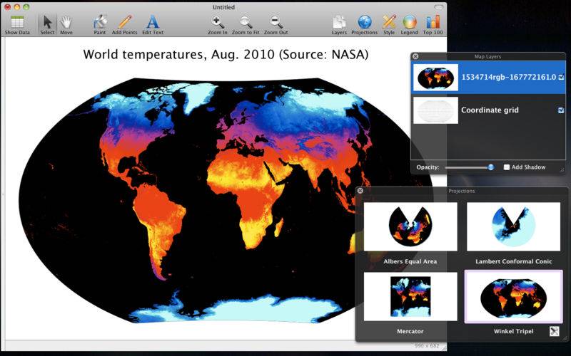
Maps created with Magic Maps have a signature, high-quality look because the program is built from the ground up using Apple's Core Graphics technology. Map layers can be managed similar to layers in Photoshop: simply drag to rearrange, check a box to add a drop shadow, use the slider to change opacity. Choose custom colors, point shapes, and line widths to create the look you want.
Magic Maps lets you choose and customize the map projection. Show the whole world with a Winkel Tripel projection, or reduce distortion with an equal area or conformal projection. Magic Maps is the only program that shows you a live preview of multiple map projections at once.
If you want to create crisp-looking maps without the fuss of traditional GIS, or if you have a lot of geographic data you'd like to explore visually, Magic Maps is the tool for you.
Core features
• Layer-based map presentation
• Multiple data fields per layer
• Timelines of data totals and averages
• Click an entity to see its associated data
• Select multiple entities with a selection box
• "Top 100" list for any data field
• Click "Play" to watch any map evolve over time
• Multi-touch zooming and panning
Flexible data import
• Import data from CSV, KML, or Shapefiles
• Copy-paste data directly from a spreadsheet
• Support for UTF-8, Unicode, Latin-1, and Windows text encodings
Versatile map export
• For print or presentations: Export vectorized PDF
• For the web: Export PNG or SVG
• For email: Command-C copies the current image to the clipboard
• For spreadsheets: Export CSV data
• For YouTube: Export QuickTime movies
• For Google Earth: Export KML
• For Google Public Data Explorer: Export Dataset Publishing Language (DSPL)
Add custom points
• Point-and-click to add a point
• Manually enter decimal degrees or Degrees-Minutes-Seconds
• Geocoding of U.S. place names (town, city, or ZIP code)
• Batch CSV import
Add custom layers
• Import KML
• Import ESRI Shapefiles
• Import NASA GeoTIFF *NEW*
• Link data to custom layers
Fully customizable appearance
• Use the Paint tool to color a simple map
• Choose colors to represent text categories or numeric ranges
• Move labels by clicking and dragging
• Leading lines connect labels to their source
• Customize any fonts, colors, and sizes
• Choose one of six shapes to represent points
• Choose solid lines or one of four dash patterns
• Optional drop shadows on shapes
• Adjustable movie playback speed
Built-in math functions
• Year-over-year change in absolute or percentage terms
• Sum multiple variables together
• Divide one variable by another
• Scale by powers of 10
• Compute rolling average
• Compute weighted average
• Interpolate missing years
Professional map projections
• Albers Equal Area
• Lambert Conformal Conic
• Mercator
• Winkel Tripel
• Instantly preview map projections
• Customize central meridian and standard parallels
Basic GIS functionality
• Count points within an area
• Aggregate point data within an area
• Draw a radius of a specified distance around points
• Compute distance to nearest point on another layer
• Perform simple queries using Smart Layers
• Area and length computations
Built-in geographic templates
• Countries of the world
• U.S. states, counties, and metro areas
• Canadian provinces, Mexican states, and a combined North America template
• Australian states and territories
• Link data against FIPS codes or state/country name
Trouble importing? Find my email in the Help menu and we'll work it out.