– Visually document and investigate a case with cellular tower locations and objects –
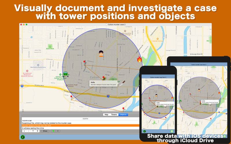
Tower points is a desktop application that lets you visually document a case (a murder case, a stalking case, a series of burglaries in the same neighbor…) with positions of cellular towers and objects. Erect dozens of tower pins on the map based on their geo-coordinates. Place an object (body, car, DNA, gun, knife, money…) at the spot where you click on the map. You can measure the distance between two objects you select or between an object and a tower you select. You want to draw a 5-mile-radius circle around a dead body? That’s a piece of cake. Actually, what you can do is document a case by placing tower pins and objects on the map and visit the actual scene with an iOS device since you can share map data with an iPhone and an iPad through iCloud Drive.
– Features –
1.Change map types: standard, satellite, hybrid.
2.Read cellular tower data from a CSV (comma-separated values) file.
3.Erect a tower pin right at the spot where you click on the map.
4.Place an object (body, blood, bottle, building, car, DNA, fingerprint, fire, gun, house, key…) right at the spot where you click on the map. There are 36 objects available.
5.Give each tower a title and a subtitle. Click on a tower to open a callout window to display its title and subtitle.
6.Give each object a title and a subtitle. Click on an object to open a callout window to display its title and subtitle.
7.Draw a line (polyline) connecting all tower pins.
8.Draw a circle nearly containing all existing tower pins.
9.Draw a circle with a given radius at any point where you click on the map.
10.Find the distance between a tower you select and an object you select.
11.Find the distance between two objects you select.
12.Find the distance between a tower or an object you select and the very spot where you have clicked on the map.
13.Save map as a picture to your disk.
14.Save progress as a document file. Open a document file to reconstruct last progress. Drag and drop a document file directly onto the map to recover progress.
15.Switch the unit of length between kilometer and mile.
16.Select the fill color of a circle, the stroke colors of a circle, the polyline.
17.Save map data you create to iCloud Drive so that you can view it with the free iOS counterpart.
18.Make an object you select visible or invisible.
19.Automatically calculate the distance between one tower and another in order.
20.Save the geo-coordinates of existing towers on the map as a CSV file to your disk.
21.Save the geo-coordinates of existing objects on the map as a CSV file to your disk.
22.Quickly share data (a small screenshot + geo-coordinates) on a tower or an object you select through Facebook, Mail, Messages, Notes, Twitter and more.
23.The fullScreen mode is supported.
24.The application supports the retina screen. (tested with 2014 2.6 GHz 13″ MacBook Pro)
25.Languages: English only.
26.Application file size: 47.2 MB.
27.The application comes with a built-in 23-page user guide. Click on the button that says ‘Learn how to use Tower Points’ in the Home screen.
– System requirements –
1. 10.12 (tested with 10.12.1 and 10.12.6), 10.13 (tested with 10.13.4)
2. 64-bit system
– Limitations –
1. This application is NOT document-based. So the user can open one case at a time.
2. In order to upload map data to iCloud Drive, the user needs an iCloud account.
3. In order to access map records they have uploaded to iCloud Drive, the user needs the internet connection.
4. In order to import data from a CSV file, a column containing latitude values must come before a column containing longitude values.
5. The user can only upload (and not download) map data to iCloud Drive since they can always back up progress at any point with a document file.
6. The free iOS counterpart only allows the user to view map data. The user cannot insert additional towers or objects to the map. They can remove circles or change colors.